Tuesday, August 31, 2010

Weston Bend State Park August 22

52 miles

Today was a pleasant, fairly easy day. My actual travel mileage was about 40 miles, maybe, but I did a lot of pottering around Watkins Mill and then Weston Bend and the city of Weston. Another miserable road today, 92. It started off cool today, but got quite hot, and I was struggling for the last few miles.

Weston Bend State Park and Weston, the city connected to it, are a couple of great places. Weston Bend is a surprisingly densely forested park with a few pleasant, easy trails and an almost magical view over the Missouri River to Kansas. If you edit out the water towers, Kansas looks like an untouched wild forest from the overlook.

There is a long, hilly road that leads to a bike/hiking trail to the city of Weston's famous Main Street. After visiting the overlook and a bit of hiking, I used the trail to ride into Weston for dinner. Honestly, there wasn't much available on a Sunday evening, and Weston is a small town, but the draw is the quaint main street and the brewery and Irish pub. The pub/restaurant, O'Malley's, was open, so that's all that matters.

I decided on the Drop Kick Ale, which turned out to be ridiculously tasty, and the fish and chips, which was less so. The decor was, well, Irish pubbery, and it seemed it would have been fun enough on a Saturday night. I recommend the city, the park, and the ale.

Tonight is the last night of my trip. 40 or so miles from here is Lawrence, where I'll set aside the panniers for a bit. I'm ready to take a rest, but I fear the rest lasting too long. I've really taken to this traveling, as hard as it is on my physically. Having a goal each day that I really must meet, satisfying that goal, then resting and planning the next goal--not to mention the adventure of the unknown--I've found it more satisfying than anything else I can think of. And this is just traveling in Missouri! I hope to do the same (or a version) in other parts of the US, then the world, as soon as I can.

Sunday, August 29, 2010

Watkins Mill August 21


87 miles

The light-play and thunder turned into some serious business. My tent is old and poorly taken care of, but beyond a little spray now and again, things seemed to be alright. However, as time passed the lightning drew closer, until I became increasingly uncomfortable lying on the ground beneath a stand of trees. Lightning struck, lighting up my tent, and not seconds later the crash of thunder, muffled by my rain tarp, then lightning, until it was so constant that I could not tell how far away the storm was--it felt that lightning would strike a tree at any moment and fry me, and that would be the end of my trip and life. So uncomfortable did I become as the lightning and accompanying thunder grew closer and closer that I decided to make a run for it. I decided to weather out the... weather... in a shower facility nearby.

When I had set my tent up, the flattest spot I could find was near a fire pit. I never light fires when by myself, only using my camp stove, so it made sense at the time. But as I took flight for my life, I noticed the pit had filled with rainwater and was about to overflow. I was so nervous about getting electrocuted, though, that I wasn't willing to do anything about it at that moment.

The storm--the first of three that night--calmed, and I walked back to my tent to find it had, indeed, flooded. Normally I would lose it at this point, and I did a little, but I quickly realized what was done was done and I had to empty out, move and dry the tent before another storm came or I'd never get any sleep.

Fortunately, my down sleeping bag wasn't wet and my mat sheds water, so I knew I could sleep once I'd toweled out the bottom of the tent. In fact, nothing except a few brochures from state parks was really damaged, so I'd escaped relatively uninjured.

More storms came, but once they were gone, I managed to sleep fitfully. I felt sleepy the next morning, but was ready to move as soon as I could dry some clothes and the foot of my sleeping bag. The sleeping bag had gotten a bit wet while I was sleeping, but I was able to dry it in the laundry (all Missouri State Parks seem to have onsite laundries) and hopefully no permanent damage was done.

This was my last long day, a mixed ride to Watkins Mill, northeast of Kansas City. I say mixed because I'd planned to take as few mega-highways as possible, but couldn't see my way around them totally. In fact, fate and the Missouri DOT had very specific plans for me, it seemed, plans that worked in my favor.

First was a closing of MO highway 23. I still have no idea why it or any of the other roads were closed, but because of it, I had to abandon plans to take a route that was longer but mainly utilized smaller roads. Instead, I followed the nasty highway 13 most of the way.

Some roads in Missouri have rather large shoulders. Some, like US 54, have shoulders that are entire lanes to themselves, where it feels like I'm riding alone with occasional breeze from a passing truck to remind me I am, in fact, sharing the road like the sign says. But most of the roads have no shoulder, a tiny, useless shoulder, or a tiny shoulder made useless by a dominating rumble strip.

Along the route I rode, MO highway 13 has all of those. Of course, none of that matters if there are no cars, but 13 seems to be quite popular. It was my least favorite part of the trip, roadwise, to this point.

One good outcome of riding 13, other than saving some time, was running into the first (and the only) traveling cyclist of the trip. I'd heard stories of a young woman who rode highway 7 (another nailbiter with no shoulder) in 109 degree weather, as well as the cyclist not fluent in American, but I'd yet to meet any.

Wayne Burton was traveling from Fairbanks, Alaska to his home in North Carolina. He must have been in his sixties, but loaded with no less equipment than I, he seemed to be setting a pace I couldn't dream of. He was headed from St. Joseph, far north of my destination for the day, to Jefferson City, far east of my starting point. I could be misremembering, as that is over 200 miles in one day, but I believe that is what he said. Perhaps he was eager to get home.

We chatted on the side of 13 despite the madness, swapping stories, then wished each other good luck. He was a nice man, and he gave me confidence that I'd be able to enjoy a long future of travel.

I reached I-70, the first road I was at all familiar with since I had left I-56 in Kansas almost a week ago. I found it strangely satisfying to have reached it, though I can't and wouldn't ride on it. I took pictures from an overpass as the semis honked at me from below.

I met another biker at a rest stop just north of I-70. He was not (yet) a tourist, but had a job ending soon and hoped to take a long trip then. He said he did the MS150 every year, no mean feat.

Near the end of the road for the day was Excelsior Springs, maybe the largest city I'd visited in Missouri. It was a pleasant, leafy city with too many hills. Here there was another fortuitous road closing: MO 10 was inexplicably closed, so they had a detour that led directly to highway 69. This was fine by me, as had 10 not been closed, I would have followed it, then had to double back about 3 miles to get to Watkins Mill, all the while not knowing there was a more direct route on a secondary road. With the detour I saved about 5 miles!

Watkins Mill is an interesting place. There is a nice open space that overlooks an expansive wooded area, and I watched from there the evening star for a while before heading back to my tent and passing out. It has a nice bike path that circles a lake. I stayed in the camp site on a Saturday with families bearing astonishing numbers of unruly kids (one called me "butthead" for no reason I knew of). The camp host, coming to collect the camping fee from me, told me that bicyclists can camp next to the camp hosts' site for $5 in Missouri state parks; she later corrected herself after speaking to a ranger, who said that this was only when all other sites were taken. Still, it is very nice to know that we are assured a spot even when the camp is full--that relieved a concern I'd had the entire trip.

Knob Noster August 20

65 miles

Today was the reverse of yesterday.

I slept well (enough) and long, but felt awful all day. I kept waiting for the energy of the day before to kick in, but despite a great tailwind and less significant hills, I trudged sluggishly through.

Nothing special happened until I got to Windsor, about half-way to Knob Noster. On a bend in the highway there, an old lady sitting under cover of her garage and watching traffic go by flagged me down while I was reading my map. She was a nice old lady, I'd guess in her early 80's. She told me the story of when she lived on the farm and had a horse she'd raised from a colt that could rustle cattle itself by kicking them with a hoof when they got out of line. She told me about riding the horse to school, and how a man had offered her $200 (a hefty sum for a horse at the time) but she'd refused. I learned everything there was to know about her horse in a remarkably short time--a good storyteller. When I left her she crossed her fingers for me and wished me good luck.

Armed with my new map from the lucky day before I was able to avoid the major roads, and found a pretty good highway with pleasant scenery. I followed it most of the way to Knob Noster.

The friendly host at the campsite told me another cyclist had been through the park, but he had set out from San Francisco on his way to New York. She said he didn't speak much "American", so I wondered if he was English and just hadn't mastered our local dialect, or if it was a more international matter. I didn't inquire.

I also passed by the Windsor trailhead of the Katy Trail, a 225 mile-long trail from central Missouri to the outskirts of St. Louis. I passed through Clinton, the current westernmost entrance, a few days earlier, but forgot to visit the trailhead there. Like the Prairie Spirit trail I rode from Ottawa, KS on my way to La Cygne, the trail is made of crushed rock, and not much to my liking for a long ride, but unlike that trail it appears to be free, with many local businesses catering to cyclists lining it. I didn't ride the trail, as I was headed north and it is laid out primarily east-west, but perhaps one day.

I'd heard good things about Knob Noster, but I've found it pretty mediocre. It is next to a highway, a train line and an air force base, so it could hardly be called "secluded". It's a lot like a city park, if that city had streets that posted 55 mph speed limits and allowed RVs in its city parks.

Apparently Knob Noster is restored to a more natural state from some sort of industrial mining, but its recovery is still underway. Many parts of the park are under rehabilitation, and perhaps the biggest draw, the equestrian/mountain-biking McAdoo trail at the southern end of the park, is closed "until summer 2010" (since that has passed, I'd say it should read "indefinitely"). If it wasn't a convenient point between HST State Park and the eastern Kansas City area, I'd avoid paying $13 to stay there again. It might be of interest to fishermen (motorized boats are not currently allowed) or military enthusiasts interested in the base next door. I'm sorry to complain about a state park, as it's better than it being a coal mine, but I was disappointed...

A bit of light-play and some thunder and finally, finally the rain has come at bedtime. I hope tomorrow is cooler because of it, I've got a long day ahead of me. Around 95 miles predicted, but always comes out to be more, so I'm hoping to get an early and energetic start.

Saturday, August 28, 2010

Harry S Truman State Park August 19

68 miles

Strange how circumstances that should have made things miserable today worked to somehow make it the best day yet.

Last night I had Mexican food, as I said. These days I accompany nearly every meal with root beer, I guess because it was so hard to find in Japan. Anyway, I think the root beer was caffeinated, because I could not sleep at all. Every time I fell asleep, I would feel I was falling and jerk awake. It lasted almost all night, until finally, at about 4 am, I conked out, to wake up at 7:30 feeling as if I was stuck to the bed, I'd slept so hard. I was groggy but I quickly packed up and hit the road.

I looked forward to a long, painful slog. I hadn't slept well in Ha Ha Tonka and the stay the motel in Camdenton had been even worse. In fact, my muscles weren't very responsive and very sore.

But something strange happened. As I rolled on the extra-wide shoulder of US 54, I started to feel good. There's no doubt I was tired, but it was as if it didn't matter, I'd make it through. I admit that has not been my attitude so far: many evenings have devolved into childish fits as I worried about getting to my destination and grew more and more frustrated as various tiny irritations seemed to get in my way. Some entire days went like this. But while I may have been worn physically, mentally I was feeling better than I had before I left Lawrence.

About a month ago I went to the Nelson-Atkins Museum in Kansas City. It has been a long time, and I was impressed by the collection. Good for a day's outing; unlike the larger museums, you can pretty much see the Nelson's entire collection in one day.

What really a struck a chord with me, though, was the Isamu Noguchi exhibition. No, not just because he was Japanese(-American); the shape and design of his monumental sculptures may have been influenced by Japanese esthetics, but I think the appeal is much deeper than that.

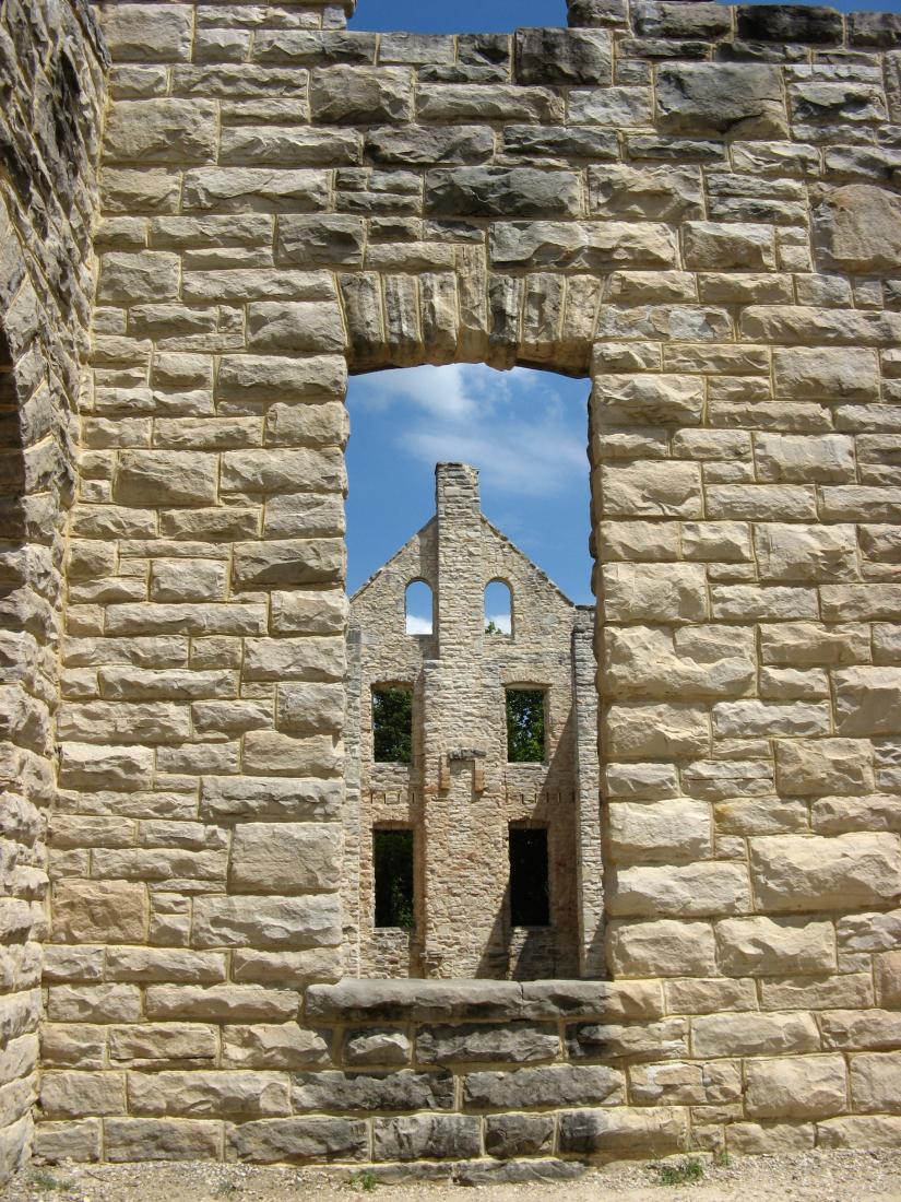
I unfortunately can't find the work online, but I recommend a visit to the Nelson to see one work of Noguchi's in particular. It is basically a square made of four stone slab walls, each maybe 7-8 feet on a side. The walls have been molded and shaped using various techniques, so that you can see beyond the walls into the interior; there is no "roof" so light gets in and you can see the inside clearly. However it is not totally clear what you are seeing on the inside. "The inside of the other walls" is the logical answer, but that's not how it felt to me.

After looking at the outside, and then through the holes, and then at the holes themselves, along with the depressions and bumps on those stone walls, I began to feel agitated. Something was wrong, or maybe it was too right. Then I felt it, in the same you feel when you see the image in a stereogram, that gasp-inducing feeling that you have seen something that isn't there but is no less real.

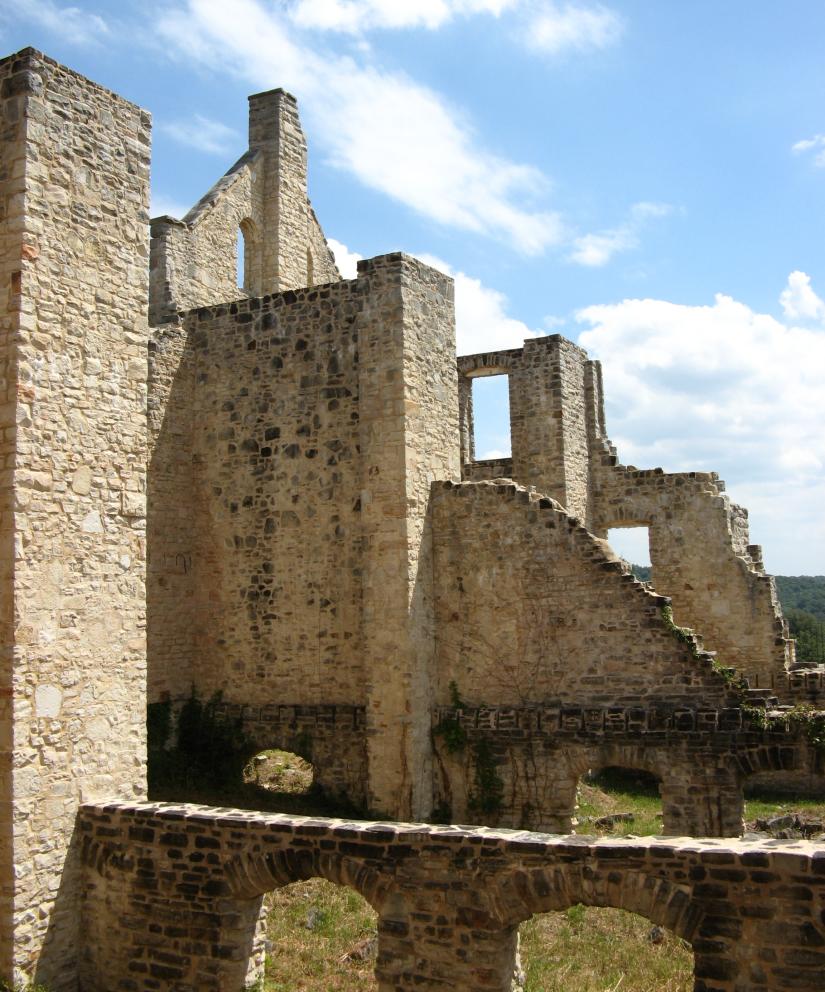
The square of walls was the physical manifestation of the way I see my life. It's hard to communicate, but I have these obstructions, these objections to the way life is, and I've built walls such that I can no longer see through very well to what is beyond. I look at the walls now, and that is my life; but sometimes I go beyond enjoying the esthetic details of the walls themselves, of the little holes, and I look beyond, through the holes. And I tell myself, "ah, those are just more walls over there", but I know that is not the whole truth. And I stand fascinated by the mystery, but because I don't know what to do with it, I go back to looking at the greyness, the straightness broken in places by unevenness, of the walls. Because that is "reality", that is what I'm "supposed" to concentrate on. My impulse was to try to wriggle through the tiny cracks, but the laws of decency, physics, and the Nelson-Atkins Museum of Art dissuaded me before the thought had even formed. I don't particularly like the walls, the mundane, but I can't seem to find anything all that fantastic about the inside of those walls yet, and I suppose I'm afraid of finding that truly there is nothing, once the wall I'm looking through is dissolved or destroyed, nothing beyond but another wall with another tantalizing view of nothingness.

I don't think another work of art has so moved me to existential sickness. It was like waking from a dream and saying "that's exactly it," then forgetting what I had discovered.But I can still feel those walls, everywhere around me, though the funny thing is, I am on the outside.

The reason I bring this up is that it seems like there is nothing but surprise and unexpected life that creates holes, or at least the ability to see through holes that are already there, in this massive wall. For an entire day, I was looking through that wall at some other view, a view provided by unforeseen circumstances. I realize this is all a bit grandiose, and I certainly didn't describe this situation to myself in these terms at the time, but whenever I think back on it now, I see that huge wall, not there for a little while.

But back to the narrative...

My good mood of the day continued even when I ran into a gravel road. I panicked at first, but after a local convinced me it did in fact lead the direction I'd intended, I decided to give it a try. I'd learned from my experience at La Cygne that while gravel may not be pleasant, it isn't the end of the world.

I soon got lost. The area was a winding mash of roads that only locals could understand; and boy was it rural. After taking what I was certain was a wrong turn, I happened on a man bailing hay. He was kind enough to stop his motor, listen to my questions, and offer both good directions and a couple of stories about the area. I liked him. He reminded me that these roads followed postal roads of hundreds of years before; probably those roads had followed ancient hunting or game roads; a fact that is hidden under the straight, reasonable roads of large cities. I headed back and followed the right path, thinking how far this man was from the everyday I've known all my life, and how different his life must be.

I was a little confused about the directions, and doubts stayed with me until, just as he said, I reached a brown house that stood at the intersection of the wrong road I'd taken earlier and the correct road I should have followed. This gave me confidence, but after nearly an hour of trudging through, I was ecstatic to find fresh pavement. So ecstatic I kissed it.

Up to this point I'd taken US 54 and the local road as a change from the road I'd taken to get to Camdenton, but now I was back on highway 7, which I'd taken before. So at the end of that local road, I was back in familiar territory. Not familiar enough, though: I thought I had enough water to get to Edwards, so I decided not to stop in Climax Springs, just east of the local road and the wrong way. It was hot, around 95 F.

In fact, I did have enough water to get to Edwards, but Edwards didn't have any services. I ended up going about 15 miles parched.

This led to a final turn of good luck that really boosted my already strangely unflappable attitude. Desperate for water, I stopped in at a woodworking souvenir shop I would never have normally visited. The place was air-conditioned, so after purchasing water and a soda, I walked around looking at the kitschy stuff and I happened to find a detailed map of Missouri in a rack of free travel brochures. I hoped to find that day a map at some convenience or auto store that would give me a better idea of the condition of the roads than the general map I had brought with me, so that I could decide that night if it was feasible to take a new route home. I took a quick look and found that every state road was mapped, so I could be sure there were roads, and that they were paved. It was a fantastic find.

So I've committed to a route north of Kansas City, then west, extending my trip by a couple of days and allowing me to continue the adventure all the way home.
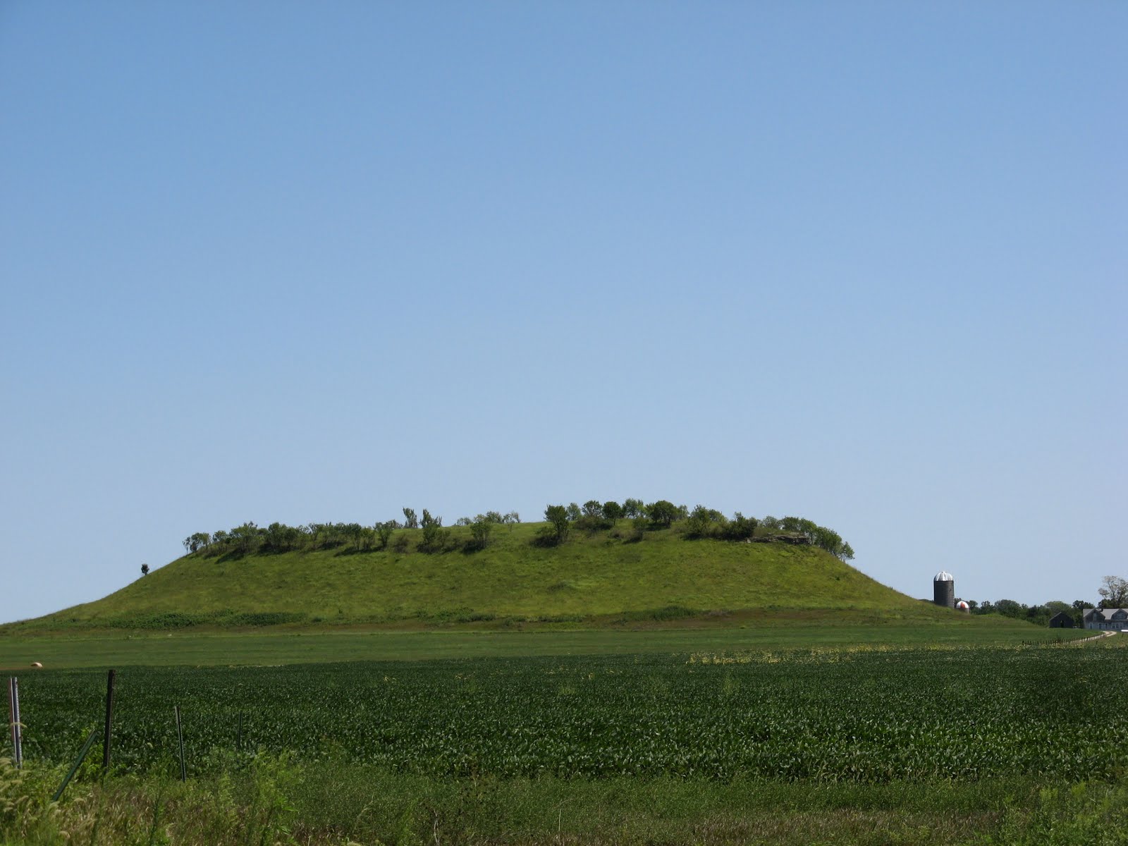
Thursday, August 26, 2010

Camdenton August 18

16 miles (plus hiking)

I'd hoped to have a bit of a rest today, and I suppose I did, with conditions. I didn't sleep well last night, between worrying about my bike and various forest noises. At one point I heard a horrific burst of howling too close for comfort; I don't know what they were, perhaps coyotes, but not dogs, I think. They must have been welcoming the moon after it reappeared from behind a cloud. Similar things happened all night.

I slept later than I'd planned, so in the end I wasn't too badly off. I originally intended to hike the Turkey Hollow Trail, the longest in the Ha Ha Tonka park and the trail where they allow through-hikers such as myself to camp. After that, I thought I'd see what time it was and perhaps go to see the famous "Castle", maybe the natural bridge, then move on.

The Turkey Hollow Trail was very pleasant and it satisfied my hiking cravings. It wasn't too strenuous, except in parts; in fact, I recommend it to anyone just beginning hiking who wants to take a longer hike. Taking it very easy, I made the 7 miles in a little over two hours, then decided to go back over the Acorn Trail that intersects with the THT and that I had visited in the afternoon before. I took a picture of what turned out to be a water tower.

I then headed over to the Castle, the real draw of the park. There are actually a fair number of smaller trails in the area of the Castle, and I ended up doing almost all of them. But the Castle and the Spring were the real highlights.

I guess the Castle was built, using local stone and timber, on the model of European castles and with Scottish masonry. The original builder never finished it, but his sons resumed work on the main "mansion", stable and water tower, and finished it years later. Twenty years after it was finished it burned down. The stone skeleton that remains was definitely worth the trip; I liked most the water tower, which can be seen from the Acorn trail, as I said before.

Next was the spring, the source of the area's appeal long before the Castle was conceived of. You can see a rich green layer through the clear waters, which flow first slowly, then in tiny rapids, then again grow sluggish near beaver dams. I read otters lived in the area, but was disappointed to only find ducks. Maybe dusk would have been a better time for a sighting.

Having exhausted most of the park in a couple of hours, I went back, packed up my tent and carried panniers back to my patiently waiting bike, which stood unmolested at the trailhead. It was a relief to have the panniers locked back in, all the parts back together and moving again.

When I first arrived at Ha Ha Tonka, I saw a sign that stated there was no camping in the park; as I've stated, this is not true because you can camp as long as you are hiking the Turkey Hollow Trail. When I originally saw that sign I despaired and considered riding back to Camdenton to stay at a motel. In the end I did stay at HHT, of course, but I became enamored with the idea of spending the next night in Camdenton, capping off a relaxing day at HHT with a bit of rest before four long days of a return trip (I will most likely return via a different route that passes north of Kansas City and that will take a bit longer than my route here). The other choices were another night at HHT, which didn't strike my fancy after the coyote orgies of the night before, or a night at Lake of the Ozarks State Park, which would add twenty miles there today and tomorrow on the way back.

This was all assuming, wrongly, that motels were plentiful and cheap in Camdenton. In fact, I spent about two hours searching for a good spot and, failing that, settled for less than good after riding 15 miles up and down the unpleasant strip-mall city strip. One inn, a chain, was charging $100 for a room, so I headed back to a smaller, locally owned motel that was still surprisingly expensive. For a highway ransom I was given the room closest to the highway and refused permission to bring my bike into the room (next time I won't ask). But I'm satisfied in the end; I unpacked my gear and headed to the local "Mexican" restaurant and had a great burrito; even after hours of hiking and biking, it was too much food and I still had to take half home.

Showered and lying on a king- or queen-sized bed, I almost find the hum of cars outside the door pleasant.

Wednesday, August 25, 2010

Ha Ha Tonka August 17

63 miles

Not such an easy day. Though mercifully the ride was only 60 miles, I suppose my first experience of three continuous days of riding has taken its toll. The hills today, too, were steep, and a couple of times I ended up walking the bike. I think I might have managed them on a more energetic day, but I wasn't willing to argue.

In Warsaw, just to the west of Truman State Park, I had a trio of pleasant experiences. I stopped at a Casey's convenience store, but before I entered a man came out. When I saw his walking stick I knew he'd strike up a conversation, and, indeed, he greeted me, asked me about my travels, and told me he'd walked hundreds of miles from Chicago to ???? (can't remember, or didn't catch it the first time). He then invited me to visit the 12 Tribes of Israel and gave me a newsletter. The world is definitely full of variety.

After I'd stocked up, a van full of teachers accosted me, saying they were on a scavenger hunt and had to ride someone else's bike for a photo as part of it. I was a bit worried the bike might topple on them, but I helped one woman get on the bike and they took a picture. They gave me some candy and hurried on to the next item on their scavenging list.

Finally, I found it was Warsaw, not Clinton, that had a nice downtown. It was quaint and yet multicultural--reminded me a bit of Santa Fe, though much smaller.

Must of the day was spent trudging through the hills. The landscape was much like rural Kansas, but with hills: farmland, pastureland and hay. I passed through Camdenton, which I was pleased to see had several Mexican restaurants. Tomorrow is to be a rest day (sort of), so I hope to stop in for a meal.

Ha Ha Tonka, just about 2-3 miles from Camdenton, was my destination for this trip, and I'm happy to say I've reached it 250 miles later. I took a quick hike before it got dark, and almost in spite of my cynical nature made more judgmental by exhaustion, I've found it to be remarkably appealing. Tomorrow I'll be taking a longer, 7 mile jog on the Turkey Hollow Trail and am really looking forward to it.

Also to some rest. Unfortunately, the camping in Ha Ha Tonka is only for through-hiking, so I'll probably end up packing up tomorrow and staying at a motel in Camdenton. It wouldn't be all that bad--in fact, it'd be quite a change for me, and I wouldn't have to leave my bike locked to a park bench at the trailhead as I did tonight. I didn't plan very well when I thought I'd stay at a hike-in campsite: I had to carry my backpack and two full panniers a couple of miles and leave my bike behind. I've considered bringing the bike to my campsite, but I'm going to leave it to fate: surely no one would try to steal or destroy a bike in a State Park? But, of course, thinking about it makes me entertain both possibilities even more.

It's noisy here. I didn't want to carry the panniers far from the trailhead, so I took the first available spot, not far enough from the road. But I'd have to walk something like three miles further to get far away from the road, and I think I'll pass.

My tent is pitched over rocks and tiny trees. My mind won't leave the poor bike: after 250 miles (plus over a thousand before I left) he's proved himself to be a sturdy companion. It feels strange to leave him locked up next to the road with all those strangers' cars. Maybe I'll go get him.

Tuesday, August 24, 2010

Harry S Truman State Park August 16

90 miles
I started the day chased by dogs: those little puppies from the night before chased after me, whining and pleading, the entire three miles or so until the gravel was replaced by pavement. There I was able to pick up speed, but they kept following me regardless and I could hear them whining and barking after me until the next town. It really was miserable, but I hope that someone in the town will pity them and take them in.

I fought a nasty headwind the rest of the day. I was happy when I was going over 10 mph; downhills that the day before would have pushed me into the mid-twenties today required effort to get up to 15. I trudged through the unchanging scenery until I made it to the town of Clinton.

I had big plans for Clinton. It was the biggest city in a while, maybe since Ottawa; it was rumored to have a classy downtown; and I was supposed to arrive at a perfect point in my day for a lunch stop. I only had 60 miles to do today, so I thought I'd have plenty of time. By the time I'd reached Clinton, though, I realized it would be pushing it to eat at a restaurant, but I had been looking forward to it all day so I decided to take the risk.

Long story short, I never found the old downtown and spent too much time looking for it. I decided to hit Arby's instead. Actually, the ham sandwiches and root beer went down just fine and I had a pleasant chat with an employee, and I got out of there with no regrets.

I then headed on to the next stage: about twenty more miles to Truman State Park. Ah, but I took the wrong road; a four-lane interstate. Though there was a "share the road" sign, it was not a very pleasant ride. But, man, it was fast: I was headed south, so no headwind. I finally figured out after about four miles that I had taken the wrong road and headed back.

I hurried across all four lanes to the opposite side and headed north back to Clinton. After a while I came upon a stooped old man fiddling with the trailer attached to his huge, red American truck. The right tire on this trailer had blown spectacularly, but he couldn't get the jack to rise high enough to reach the bottom of the trailer. Being uninclined mechanically (unless it is a bicycle we are talking about), I was pretty useless. My brilliant suggestion was that he call someone. Luckily, a helpful man in his own huge truck came to the rescue. I watched while he put the jack under the axle of the trailer, explaining he himself had had a trailer blowout just the week before, and deftly replaced the blown tire. I think I replaced the bolts that had secured the spare. I felt absolutely useless (a third wheel, so to say), but I decided to see the thing through and did. The old man was grateful, and then we parted.

The next major milestone was halfway from Clinton to Truman Park, a city named Tightwad. I had seen the name years before and had from that time been curious what sort of city would call itself such. Apparently, a city starving for citizens: the population was somewhere around 70, with a lone (but very large) gas station and souvenir shop. I bought water, but passed on the Tightwad coin purse.

Outside Tightwad the road quickly became more hilly and forested, and I soon found Truman Park and a suitable campsite.

I was able to make food without anyone around to whine and beg, so I reconstituted some absolutely delicious black bean dip from the health food store and ate it with corn chips. I was in heaven. Then I ate a Malaysian dish mixed with camp-cooked quinoa, and was in another layer of heaven. Try eating after 50-100 miles on a bike: saltines taste like Ritzes, bananas taste like a banana split, and Gatorade tastes like Chimay. I will be eating at this restaurant again.

I missed the sunset in my food orgies. It's oddly warm inside my tent even without the rain flap. Once again a half moon, tonight a true half-moon, rose. I noticed it while biking, that hint of white against a clear, blue sky. I'm a bit too tired to enjoy it fully. The tree frogs echo, then harmonize, then echo. I let into my tent little bugs that look like white fairies. They don't care that they look like fairies, of course, but I think they are better than mosquitoes. I'm looking forward now to sleep, a late morning, and an easy day tomorrow (please!).

Trip to the Missouri Ozarks


View Larger Map
I've just gotten back from a trip to Ha Ha Tonka, in the Missouri Ozarks. It took a week and almost 600 miles, and was quite an experience. (The map above isn't quite right in a couple of minor places).

I got the idea of going for a long ride after looking at pictures of friends back in Japan climbing mountains: I really miss the mountains there, mountains anywhere! As many know, there aren't too many mountains in Kansas, so I was out of luck locally. But if I went somewhere, say by bicycle?

I had originally thought about going to the Arkansas Ozarks; not the tallest mountains in the world, but still an interesting challenge. But I couldn't figure out a way to make it down there and back in less than a week, and any more time seemed just too long. I don't really know why, now; something about wanting to not spend too much time neglecting the job search. So I settled on the Missouri Ozarks, and one of the closest spots, Ha Ha Tonka, was also highly recommended, so that's where I set my destination.

I meant to leave two weeks ago, but the day before departure I grasped that I just did not have the right equipment for the job, and I used that as an excuse not to set out just then, because it sounded tougher than that I was just waiting until the temperature got below 100 F. So I stocked up on the correct equipment, studied maps, enjoyed the air conditioning and waited a week. I left last Sunday, August 15th.

I took a diary while I was on the road, so I'll just be copying that in here verbatim. It may get a bit wordy, so I hope you'll forgive any unnecessary length. I'll be putting each day except the first in separate entries as I get to them. The first is below:

Aug. 15
96 miles
La Cygne Lake


Today I worked my way to La Cygne Lake via the Prairie Spirit Trail. Relatively uneventful, with your standard eastern Kansas farm scenery. Soybeans, corn, cows and horses. And hay, lots of hay.


The Prairie Spirit Trail, from Ottawa to Iola, is quite an accomplishment. It runs for 51 miles free of automobiles, mostly a pleasant, tree-lined jog.


I wouldn't really take it again for a couple of reasons: it costs money (I'm happy to pay, once) and it is bedded with packed gravel. The gravel really slowed me down and I'd prefer the paved road running parallel and not half a mile away if I were to go that way a second time. But it is great for a relaxed outing, say with kids. I certainly don't want to detract from these rails to trail efforts; like Missouri's extensive Katy Trail, these paths are a step in the right direction, though I'd like to see more gas money going to it than coming out of my pocket.

From the Scipio trailhead of the Trail, I turned east for a straight shot to La Cygne (pronounced La Seen). This, again, was uneventful, until I reached the city of La Cygne near the lake of the same name that was built to cool a power plant and where I hoped to stay the night. I had manipulated Google Maps' surprisingly useful bike directions to make them avoid I-69 and, despite its better judgment, it led me to a gravel road. I'm not much for gravel with my narrow tires, so I walked the bike a few times, fell down and scraped my knee, and screamed more than a few times (it was late in the day and I was tired). But by the end of it I'd learned a bit (it's easier to navigate gravel at a slightly higher speed; at a slower speed the rocks throw off your momentum more, making it easier to slide and fall) and in the end it didn't take me all that long.

I have never been so happy to see smokestacks, though. As I've said, the lake was built to cool a power plant, so when I saw those familiar white and orange towers, I knew I couldn't be far from the lake and my campsite. I arrived a bit later at an unmarked campground, welcomed first by a live but burning tree and then by abandoned twins.

The tree was and still is a mystery: a well-constructed pile of kindling, sticks and larger wood meant for a camp fire was standing piled nearby, but a large fire had been lit in the bole of a tree. I was looking for my own campsite and that didn't look very promising, so I moved on.

The abandoned twins are a couple of black puppies that first hounded a couple of recreational fishermen until they scared them off, and who then came and begged in my direction. They've taken up residence here, near my campsite. They're actually pretty well-behaved, and I feel sorry for them. I say that because they are sleeping now and not bothering me.


The coolest day this week is now cooling even more, and the sunset illuminates an odd, puffy formation of cloud. A near half-moon has come out, and it is a restful end to a mostly positive first day.